
Outer Banks National Scenic Byway
Posted on 08/26/2015 in Uncategorized.
Outer Banks National Scenic Byway
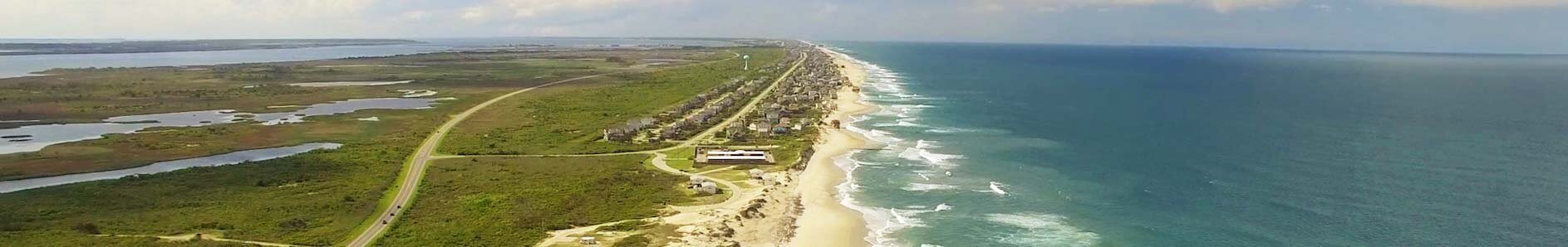
Take the road less traveled. Take the time to experience the actuality of North Carolinas Easternmost parts along the coast of the state’s barrier islands. Currently the Outer Banks National Scenic Byway is made up of nine barrier islands – or banks. The islands protect the mainland coast from the Atlantic Ocean’s, at times, compelling winds and water.
The length of the secluded road is 142.5 driving miles.
The driving time is 6.5 hours – including 3.5 hours on two ferries.
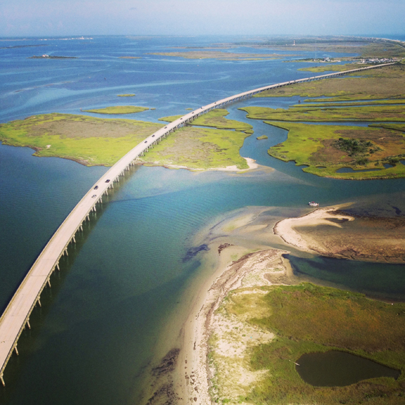
The byway begins in the Outer Banks region and ends in the Crystal Coast region. The Outer Banks National Scenic Byway passes through one of the nation’s great coastal landscapes, tidal marshes, wind-swept dunes, and alluring sounds border the roadway. The byway also includes two national seashores, Cape Hatteras and Cape Lookout. There is two national wildlife refuges – Pea Island and Cedar Island. The barrier islands are separated away from the mainland by six different sounds ranging from three to 40 miles wide. From North to South they are: Currituck, Albemarle, Roanoke, Pamlico, Core and Bogue.

The oceangoing culture of the 21 coastal villages along the road is what makes this route so unique. Each maritime village shares a common cultural heritage which is shaped by the well know barrier islands and three shallow sounds – Pamlico, Core and Back. During the drive visitors will notice that the tiny villages are held together by locally owned businesses with barley a chain business in sight. The residents of these villages build boats, fish and hunt, operate ferries, guard the coast, tell stories and provide services to visitors. Fishing and hunting as livelihoods are keys to this culture that goes along with living on the coastal edge. Byway villages are held to a significant national history, a collection of the nation’s earliest civil works. This includes four historic lighthouses and eight early U.S. Life-Saving Service or U.S. Coast Guard stations. The four lighthouses along the byway are Bodie Island Lighthouse, Cape Hatteras Lighthouse, Ocracoke Village Lighthouse, and Cape Lookout National Seashore Lighthouse.
Take the drive on The Outer Banks National Scenic Byway and get a feel for how life was like before the hectic schedules and tourist-driven cities. The Outer Banks National Scenic Byway begins in the north at Whalebone Junction. The joining of US 64-264, US 158, and NC 12 in Nags Head, Dare County, North Carolina. Travelers following the Byway’s NC 12 south can see the Atlantic Ocean on the east and the Pamlico Sound on the west. The road crosses over Bodie and Hatteras islands in Dare County, Ocracoke Island in Hyde County and Down East in Carteret County to end on the west side of North River at the intersection of US 70 and Merrimon Road. The byway includes two ferry rides. One free, between Hatteras and Ocracoke Islands. The other, between Ocracoke Island and Downs Easts Cedar Island. The Scenic Byway ends in Beaufort in the Down East region of North Carolina.
http://www.visitnc.com/trip-idea/outer-banks-national-scenic-byway-1
http://gardenandgun.com/blog/back-road-trip-outer-banks-scenic-byway
New findings on The Roanoke Island Missing Colony
Posted on 08/17/2015 in Uncategorized.
New findings on The Roanoke Island Missing Colony

One of the first few thoughts that come to mind when you think of the Outer Banks includes Roanoke Islands Lost Colony. Chances are if you have ever visited Manteo or the OBX in general, then you have seen the outdoor drama The Lost Colony produced by the Roanoke Island Historical Association. This is a non-profit association created to help celebrate the history of the first English colonies on Roanoke Island, North Carolina. The play is was generated to honor the founders of The Lost Colony through drama, education, and literature.
For those of you that don’t know the story about the disappearance of The Lost Colony, let’s bring you back to the 16th-century. In July of 1587, 117 English men, women, and children came ashore on Roanoke Island with a commission from Elizabeth I to establish a permanent English settlement in the New World. An Englishmen named John White helped lead the settlers to Roanoke Island, which is located inside the chain of barrier islands that is today called the Outer Banks. It was Sir Walter Raleigh’s second attempt to colonize North Carolina, but the first to include civilians and families. White’s granddaughter, Virginia Dare was the first child born in the New World to English parents just weeks after their arrival. A resupply trip sent White back to England that same year. A naval war with Spain delayed his return. Three years later in 1590, when English ships returned to bring back supplies, the settlers had vanished. The only clue left behind was the word “Croatoan” carved into a fence post, and the letters “CRO” on a tree. Many believe these referred to what is now Hatteras Island, 50 miles south of their settlement.
On and off for the past three years, Nicholas M. Luccketti and his archaeology team have been working along the coast of the Albemarle Sound trying to uncover more clues on this mystery. Mr. Luccketti and colleagues with the First Colony Foundation have been digging up parts of the shores and hillsides of the Albemarle Sound hoping to find traces of the colonists. The dig site where they have been working is located in a secluded cove off of a creek in Merry Hill N.C., they call the spot Site X. The archaeologists have not found evidence of structures there, but have found ceramics and other material of European origin that might have come from Roanoke colonists. In an article posted by The New York Times Luccketti says “I’m trying to make sure that I say this correctly. We have evidence from this site that strongly indicates that there were Roanoke colonists here.”
New findings means more questions and more excitement. Some scholars who have seen the evidence are supportive of the findings, but at least one sees the evidence as not enough to draw solid conclusions. All agree more digging is needed in order to determine the findings at Site X. The latest findings include fragments of earthenware and pottery, a mashed metal rivet, and a piece of a hand-wrought nail. All were found in a shallow pit on a hillside above the Albemarle Sound.
In 2012 was when the most alluring clue was brought to attention by the British Museum when they re-examined one of White’s coastal maps for the First Colony Foundation. X-ray spectroscopy and other imaging techniques revealed that a patch hid a four-pointed blur and red star on the western end of Albemarle Sound. That certain spot, near the outlets of the Chowan River and Salmon Creek, more or less corresponded to White’s reference to a site 50 miles inland, Croatoan (now Hatteras Island). Eric Klingelhofer, a vice president for research at the foundation and a history professor at Mercer University in Macon, GA says “We need to know more. This whole story is a blank page, a blank chapter of history, and I think archaeology is the only way to come up with answers.”

If you would like to read more about the new findings of the Roanoke Island Colony check out this article the New York Times posted.
http://www.nytimes.com/2015/08/11/science/the-roanoke-colonists-lost-and-found.html?_r=0